Rainstorms Predicted, But not Enough to Douse Extreme Fire Dangers
Trevor Phipps
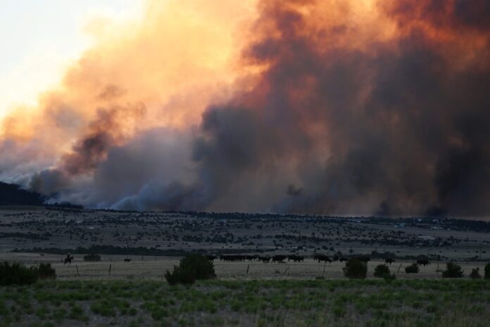
As devastating wildfires continue to blaze across the country’s western states, the state and region will remain on a red alert status with fire dangers escalating to a level not experienced in recent years.
Many fires are scorching the state, with the Aspen Acres blaze gaining prominence as the largest in the country.
Teller County has so far avoided the brunt of the wildfire season, but a few fires have recently provided brief scares. One of the biggest issues of local concern is the proximity of major blazes like the Aspen Acres fire. These have led to the Ute Pass region becoming engulfed with smoky, low air quality condition that endanger those with health problems.
On July 6, a list of air quality amongst the world’s major cities put Denver as the 17th worst. Due to wildfire smoke, Denver and most of the state were deemed to have worse air quality than any other U.S. city.
Colorado’s fire dangers have escalated, as there are now so many wildfires burning across the state that firefighters from outside areas, including Alaska, have been shipped in to help. As a result of these growing dangers, our region is not out of harm’s way.
Two new lightning-caused fires broke out in El Paso County near the Teller County border. Authorities said the Gold Camp and St. Peters fires remained small, each burning less than an acre.
On July 6, another fire ignited about six miles southwest of Woodland Park off Rampart Range Road. Crews responded to the blaze at around 5:30 p.m., and they announced that they had it fully contained by 7 p.m. The fire burned a tenth of an acre and the cause of it is unknown.
The biggest fire in the country though has started to spread north and threaten Fremont County, which is Teller’s southern neighbor. At press time, the Aspen Acres Fire burning west of Pueblo had torched over 93,000 acres. Overall, more than 260 structures have been lost.
Over the Fourth of July holiday weekend, the fire grew and spread mostly east. Fire crews were able to reach around 14 percent containment by July 5, but then the next day it started to spread north and grew substantially.
As of last Tuesday, the fire was 15 percent contained with the containment being on the east side near Colorado City. Mandatory evacuations were lifted for most of Colorado City as the fire seemed to change directions.
The blaze then prompted more evacuations in Fremont County as it spread northern towards towns like Wetmore and Florence. The federal prison complex that is home to the infamous Super Max penitentiary was on lockdown as it sits right on the mandatory evacuation line.
While crews from across the state and country work to contain the Aspen Acres Fire other major wildfires continue to burn in other parts of Colorado. At press time, the Willow Fire west of Leadville had burned over 4,300 acres and was five percent contained.
The Gold Mountain Fire near Ouray had burned more than 31,000 acres and was only two percent contained. Further west, the Snyder, Doe Canyon and Ferris Fires also continue to grow.
Stormy Weather Could Pose More Challenges
As monsoon season is slowly trying to make its way to Colorado, the small number of thunderstorms the state has received haven’t helped much. Experts say that the recent thunderstorms have brought about high-speed winds that have helped fuel and grow the current wildfires. Lightning strikes have also caused some new blazes to ignite across the state.
Local residents and emergency responders have hoped that this year’s upcoming monsoon season will help provide the moisture it needs to quell the extreme fire danger risk. But unfortunately, long-term weather forecasts seem to paint a different picture.
Following the July 4th holiday, the area did receive some thunderstorms and a little rain, but it didn’t amount to much. Hot and dry weather then prevailed again, and this trend is expected to continue until Wednesday or Thursday.
The area is then expected to have a good chance of thunderstorms every day from this Wednesday into the first half of next week. However, the thunderstorms aren’t expected to produce large amounts of moisture.
For the near future, most long-term forecasts available online show intermittent weather throughout July and into August. The forecasts all show a mix of thunderstorms and hot dry days throughout the rest of the summer.
The Farmer’s Almanac also shows a mix of hot weather and scattered thunderstorms for the remainder of July. The Almanac predicts that the Ute Pass region will receive about an inch less moisture than what we normally get for an average July.
During August, the Farmer’s Almanac forecast shows weather cooling down a little and there will be more chances of rain and thunderstorms. The region could see an inch more in rain than the average for August. But on the downside, the rain the area does receive probably won’t be enough to make a major difference in combating the extreme fire conditions.
In fact, it is probably fair to say that dry conditions prompting the Stage 2 fire ban in Teller County and other parts of the state will continue throughout the summer. Hopefully, with the return of El Nino this fall and winter high moisture levels will balance things out.