


Key Messages:
| |
Recent Updates:
|
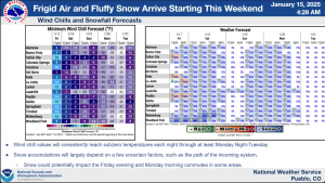
Below are key details and preparedness tips for the upcoming arctic airmass and snow event starting Friday night (lasting into Tuesday or longer). Please share this information with your teams, agencies, and communities to ensure everyone is prepared and safe. Attached are the NWS Decision Support package and Ready.gov winter-storm Hazard Info sheet.
Key Weather Updates:
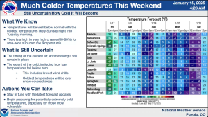
- Cold Temperatures: Subzero temperatures are expected nightly through Tuesday morning.
- Snowfall: Light, fluffy snow likely Friday night and Saturday, with possible additional snow Sunday night into Monday. (Amounts may vary closer to the event.)
Winter Storm Risks:
- Increased risk of car accidents, hypothermia, frostbite, and carbon monoxide poisoning.
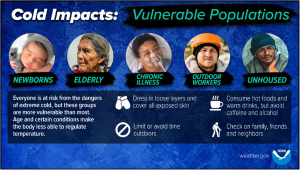
- Extreme cold and storms can disrupt power, heat, and communication. Vulnerable populations (older adults, children, pets) are at higher risk.
Preparation Tips:
- Home:
- Insulate, caulk, and weather-strip to keep out cold.
- Prevent frozen pipes. Test smoke and carbon monoxide detectors with battery backups.
- Stock essential supplies (food, water, medications, batteries).
- Emergency Kits:
- Home: Include necessary items for several days without power.
- Car: Pack jumper cables, sand, flashlight, blankets, warm clothing, water, and non-perishable snacks.
- Stay Safe:
- Avoid carbon monoxide poisoning: use generators and grills outdoors, 20 feet from windows.
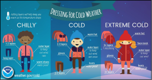
- Limit outdoor exposure: wear layers, watch for frostbite/hypothermia signs, and avoid overexertion.
- Stay off roads when possible. If stranded, stay in your car.
Frostbite & Hypothermia Awareness:
- Frostbite Signs: Numbness, pale or waxy skin. Actions: Warm affected areas gently—avoid massage/heating pads.
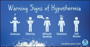
- Hypothermia Signs: Shivering, confusion, slurred speech. Actions: Warm the center of the body first; keep dry and covered.
Generator Safety:
- Use generators outdoors, 20+ feet from windows.
- Install carbon monoxide detectors on all home levels.
- Avoid wet conditions; refuel only after cooling.
For additional support, contact Low Income Home Energy Assistance Program (LIHEAP) for help with heating costs or home weatherization.
NWS Pueblo Winter Weather and Cold Update – Thu, Jan 16 248 PM


